Bishan-Ang Mo Kio Park: Guide to Design, Trails & Access
If you’ve ever walked through a concrete channel one moment and found yourself beside a winding natural river the next, you’ve probably stumbled into Bishan-Ang Mo Kio Park. This 62-hectare green space sits in the heart of central Singapore, and it draws more than 3 million visitors each year (Landezine) — a number that speaks to something rare in dense urban Singapore. The park has a history stretching back to 1988, but its most remarkable chapter began when engineers decided to tear out a concrete canal and let the Kallang River breathe again.
Size: 62 hectares · Opened: 1988 · Reopened: March 2012 · Location: Bishan and Ang Mo Kio, central Singapore · Status: Largest urban park in central Singapore
Quick snapshot
- 62 hectares of green space (National Parks Board Singapore)
- Prime Minister Lee Hsien Loong opened the park on 17 March 2012 (Wikipedia)
- Over 3 million annual visitors (Landezine)
- Precise total trail length (various segments reported but no unified official figure)
- Exact visitor split between River Plains and Pond Gardens zones
- 1988: Park opened as Bishan Park
- 2007–2010: Design phase
- October 2009 – February 2012: Construction
- 17 March 2012: Official reopening
- Ongoing PUB ABC Waters programme expansions to other canals
- Growing PCN integration connecting Bishan-Ang Mo Kio Park to wider trail networks
Key facts about the park at a glance are summarised in the table below.
| Field | Value |
|---|---|
| Size | 62 hectares |
| Location | Bishan and Ang Mo Kio, Singapore |
| Opened | 1988 |
| Reopened | March 2012 |
| Key Project | PUB Active, Beautiful, Clean Waters |
| Annual Visitors | Over 3 million |
| Naturalised River Length | 3 km |
| Construction Cost | 76 million SGD |
Bishan-Ang Mo Kio Park design
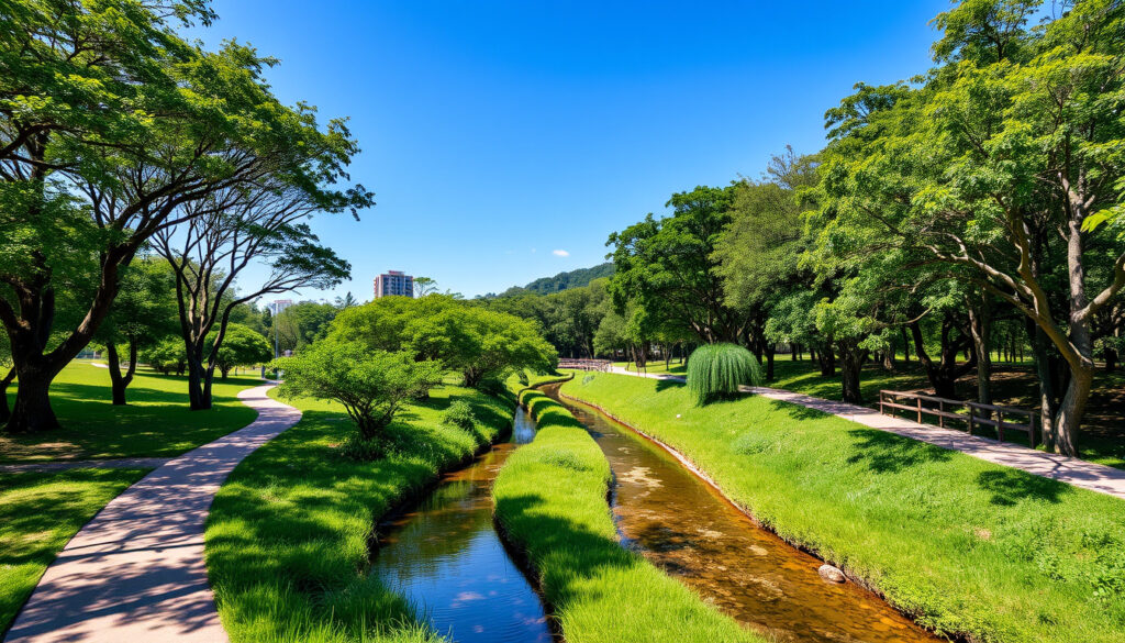
The park’s most striking feature is the naturalised Kallang River, a 3 km stretch that replaced a 2.7 km concrete canal (DREISEITLconsulting). This was the first time in Singapore that a concrete canal was fully naturalised and woven into an urban park — a project so significant it won the American Society of Landscape Architects’ 2016 Outstanding General Design award (ASLA Awards). The redesign wasn’t cosmetic. Engineers widened the river’s flood corridor from 17–24 metres to nearly 100 metres, boosting conveyance capacity by approximately 40% (ASLA Awards). The concept behind it all is elegant: a floodplain that functions as parkland in dry weather and absorbs stormwater during heavy rain.
PUB, Singapore’s national water agency, commissioned the project alongside the National Parks Board as part of the Active, Beautiful and Clean Waters (ABC) Programme, which PUB launched in 2006 (Wikipedia). The design team used soil bioengineering — seven distinct techniques combining vegetation, natural materials, and civil engineering — to stabilise the new riverbanks (Japheth Lim Blog). A vantage point near the water uses recycled concrete from the old channel, a quiet nod to what once stood there (Ramboll engineering consultancy).
Marymount Road cuts through the park, dividing it into two distinct characters. The eastern side, River Plains, leans toward open lawns and the meandering river. The western side, Pond Gardens, clusters attractions like the water playground, the Gym Pod, and a foot reflexology garden described as one of the largest in Singapore (Little Day Out guide).
For urban planners worldwide, Bishan-Ang Mo Kio Park proves that concrete infrastructure and ecological design don’t have to be enemies. The 40% increase in flood conveyance came without sacrificing amenity space — an equation more cities need to solve as climate adaptation tightens.
The implication for other dense cities is that retrofitting concrete waterways can yield both ecological and recreational dividends simultaneously.
Bishan-Ang Mo Kio Park nearest MRT
Getting to the park by train is straightforward. Bishan MRT Station on the North-South Line is the nearest station, roughly a 10-minute walk from the park’s Bishan Road entrance (The Gees Travel). From there, bus services 50, 53, 55, 58, and 71 depart from the interchange and stop near the park (National Parks Board Singapore). The Thomson-East Coast Line’s Bright Hill Station offers a second access point, particularly useful if you’re approaching from the Upper Thomson side (The Gees Travel).
The park sits between Bishan Road on the east, Marymount Road through the centre, and Upper Thomson Road on the west (TripAdvisor visitor guide). That triangle of access points means most residents in the Bishan-Ang Mo Kio heartland are within a 15-minute walk of the park’s boundaries.
For residents without cars, the Bishan-Ang Mo Kio corridor is exceptionally well-served. Five bus routes plus two MRT lines converge on this park — something that can’t be said for most green spaces in land-scarce Singapore.
Bishan-Ang Mo Kio Park trails
The park’s trail network revolves around the Park Connector Network (PCN), a government initiative linking green spaces across Singapore. The park connector running along Bishan Road and Ang Mo Kio Avenue 1 spans 3 km and is fully wheelchair accessible (National Parks Board Singapore). Jogging and cycling tracks run through both the River Plains and Pond Gardens zones, with the riverside paths offering the most scenic routes (National Parks Board Singapore).
Connecting the PCN to the wider network is seamless. From the park, you can head east toward the Central Catchment Nature Reserve or west toward the Thomson area, making Bishan-Ang Mo Kio Park a natural hub rather than a dead end for trail users.
The exact combined trail length within the park isn’t officially aggregated in one place — figures exist for the PCN segment and riverside paths separately, but no unified total. Visitors looking for a precise distance should plan around the park’s 62-hectare footprint rather than a single mileage figure.
Bishan-Ang Mo Kio Park map
The park stretches roughly 3 km from its Bishan Road entrance to the Upper Thomson area. Marymount Road acts as the central dividing line, with Car Park A serving River Plains on the east and Car Park B serving Pond Gardens on the west (Little Day Out guide). The naturalised river section runs through the centre, flanked by wide lawns, tree clusters, and the main activity zones.
The layout reflects the floodplain concept — lower-lying areas near the water host flexible lawn space that can handle occasional inundation, while higher ground holds fixed amenities like playgrounds and the dog run. This zoning is why the park feels spacious despite serving such a dense residential catchment.
Bishan-Ang Mo Kio Park photos and features
Visually, the park offers several standout zones. The naturalised river with its gentle curves and vegetated banks is the centrepiece, best photographed from the vantage point built with recycled concrete. Pond Gardens draws families for the water playground and the foot reflexology path — a textured walk that’s as functional as it is scenic. The three playgrounds scattered throughout cater to different age groups (Ramboll engineering consultancy), while the dog park near Pond Gardens is a dedicated off-leash area (TripAdvisor visitor guide).
Dining options include GRUB Pasta Bar and a McDonald’s outlet within the park grounds (Little Day Out guide), making it practical for half-day visits. The therapeutic garden near the water playground adds a quieter dimension for those seeking sensory-friendly environments.
Timeline
The key milestones in the park’s history are documented below.
| Year | Event |
|---|---|
| 1988 | Park opened as 62-hectare green space |
| 2007 | Design phase began |
| 2009 | Construction started (October) |
| 2012 | Construction completed (February); park officially reopened (17 March) |
The pattern shows a rapid three-year construction timeline that compressed design and build phases to achieve the 2012 reopening target.
What we know for certain
- The park covers 62 hectares
- It opened as Bishan Park in 1988
- Construction ran from October 2009 to February 2012
- Prime Minister Lee Hsien Loong presided over the 17 March 2012 opening ceremony
- The river was naturalised from a 2.7 km concrete canal to a 3 km natural channel
- The National Parks Board manages the park
- Over 3 million visitors come each year
What’s still unclear
- Unified total trail length within the park
- Exact visitor split between the two main zones
- Which construction cost figure (SGD 8.5 million vs 76 million) is authoritative
What people say
Bishan-Ang Mo Kio Park is a great place for families to have a fun day out. — National Parks Board Singapore (official park description)
The park was upgraded through community improvement plans, transforming a concrete canal into a naturalised river integrated with parkland. — Ramboll (project profile)
Related reading: Spectra Light Show · Wings of Time
After exploring the park’s trails and river, check out the nearby former Ang Mo Kio Swimming Complex, which served locals for 41 years before its recent sports park redevelopment.
Frequently asked questions
Is Bishan-Ang Mo Kio Park free to enter?
Yes, the park is completely free to enter. All open spaces, trails, playgrounds, and the dog run are accessible without any admission fee.
What activities are available at Bishan-Ang Mo Kio Park?
The park offers jogging, cycling, playgrounds for children, a water playground at Pond Gardens, a foot reflexology garden, a dog run, a Gym Pod, and a therapeutic garden. Casual dining is available at GRUB Pasta Bar and McDonald’s within the grounds.
Is Bishan-Ang Mo Kio Park pet-friendly?
Yes. The park includes a dedicated dog run where dogs can be exercised off-leash. Keep dogs on leashes in other areas of the park.
What time does Bishan-Ang Mo Kio Park open?
The park is open 24 hours for trail access. Individual facilities such as the water playground and dining outlets operate on their own schedules, typically from morning to early evening.
Are there restrooms in Bishan-Ang Mo Kio Park?
Yes. Restrooms are available near the main activity zones, including facilities near the Pond Gardens playgrounds and the River Plains entrance. All restrooms are wheelchair accessible.
Can I cycle in Bishan-Ang Mo Kio Park?
Cycling is permitted on designated tracks throughout the park. The well-maintained cycling paths run alongside the jogging tracks and connect to the wider Park Connector Network.
Is Bishan-Ang Mo Kio Park wheelchair accessible?
Yes. The 3 km park connector along Bishan Road and Ang Mo Kio Avenue 1 is wheelchair accessible, and the restrooms throughout the park meet accessibility standards.
More related posts
 When the Camellia Blooms: Worth Watching? Ending & Killer
 Race Card & Results: Today, Tomorrow, UK & Irish
 Tan Teng Hock Unlicensed Instructor: Jailed After 100+ Students
 Moon Chae-won: Age, Height, Husband, K-Dramas and Bio
 300 Yen to SGD – Current Rate and Conversion Guide
 Home Cleaning Services Singapore: Compare Prices & Reviews
 Cast of The Price of Confession: Actors & Roles (2025 K-Drama)
 Chara Brasserie Buffet Price Singapore: $58++ Lunch Deals